Improved flood control and water quality with a smart water solution
See how the city of Vejle in Denmark protects its streets from flooding

Vejle needed to operate its existing two flood control structures in a smarter way.
The dilemma: Protecting one part of the city from flooding by a particular operation of the diversion structure could easily cause flooding in other parts of the city. Similarly, the water quality of the river will suffer if the flood gates are closed for a prolonged period of time.
Implementation of SMART Water Vejle Solution in close collaboration with Vejle Municipality, Vejle Waste Water Utility and Aalborg University.
Solution highlights (short):
Improved flood protection with lesser flood damages
Smarter operation of flood control structures improves the quality of water in the river
The implemented early warning system results in better emergency management
High flood vulnerability due to natural geographic characteristics
The city of Vejle is located at the bottom of a steep valley where two rivers join and discharge into a fjord, making it particular prone to flooding. Historically, Vejle has frequently suffered from flooding due to intense rainfall either in the city or over the river catchments, and by high water level – caused by storm surges – in the fjord.
Furthermore, the impact of climate change has increased the frequency and severity of flooding as rainfall events get more intense, average sea level continue to rise and storms surges become more frequent.
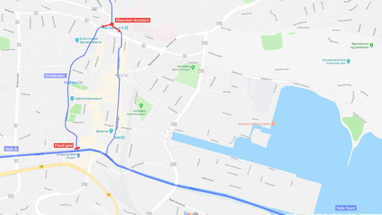
In order to provide better flood protection, the city has invested in a flood gate at the bottom of river Omløbsåen where it meets another river, Vejle Å.
When closed, the flood gate will prevent high water levels in the fjord from entering Omløbsåen, where it otherwise would cause flooding. Three motor-driven sluice gates are also located further upstream in Omløbsåen, allowing automated and remote control.
(Hover over the image to zoom)
What is the best way to operate the flood control structures?
One of the main challenges for the city and the operators of the two flood control structures was to define a balanced set of rules for the operation of the structures.
The dilemma: Protecting one part of the city from flooding by a particular operation of the diversion structure could easily cause flooding in other parts of the city. Similarly, the water quality of the river Omløbsåen will suffer if the flood gates are closed for a prolonged period of time.
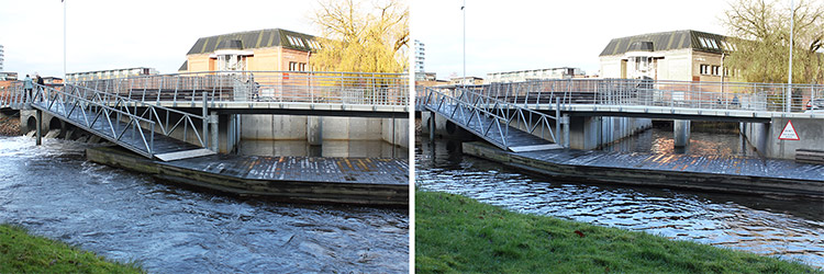
Flood control structure with gates closed and pumps running (left) as well as gates opened and pumps turned off (right).
Real-time control requires real-time data and forecasts
In close coorperation with Vejle Municipality, Vejle Waste Water Utility and Aalborg University, we implemented the SMART Water Vejle Solution.
The solution defines the operational rules on activating and managing the flood control structures. Determining the best way to operate the flood control structures not only requires information about the past and current state of the fjord, rivers, drainage system and rainfall – it also requires forecasts of the same.
In order to provide the required forecasts and to apply these for real-time operational decisions, as well as to facilitate an easy overview, the following were implemented:
Implementing the SMART Water Vejle Solution led to significant positive results for Vejle.
Integrated management of fluvial, pluvial and coastal flood risk
With the implemented approach for integrating radar data with coupled models for ground water, rivers and urban storm water drainage, combined with forecasted water levels in the fjord, the city of Vejle has is now able to manage fluvial, pluvial and coastal flood risk in an integrated way.
Maximised benefits of investments in flood control structures
With real-time control of the flood control structures using model based real-time forecasting and operational rules, the city is maximising the benefits from the significant investment made in the flood gates and diversion structure. Protection from flood caused by fast river runoff is improved, along with better water quality of river Omløbsåen.
Supporting the flood emergency team
The implemented solution for data integration and visualisation provides an overview of:
Having an early warning system results in safer and quicker flood emergency management.
Vejle Municipality (Vejle Kommune in Danish) is the municipal authority in the city of Vejle and surrounding smaller cities, with a combined population of approximately 113.000. Vejle Waste Water Utility (Vejle Spildevand in Danish) owns and operates the waste and storm water network as well as waste water treatment plants within Vejle Municipality.
Automated and model based real-time flood forecasting and real-time control of flood structures using MIKE SHE, MIKE HYDRO River and MIKE URBAN (now MIKE+) models, integrated with DIMS.CORE and MIKE OPERATIONS.