 GRAS - providing innovative mapping products and solutions based on satellite and aerial imaging within the DHI Group – has completed a project on ‘Satellite remote sensing in support of UN-REDD’ for the Cambodian Forestry Administration.
UN-REDD is the United Nations collaborative initiative on Reducing Emissions from Deforestation and forest Degradation (REDD) in developing countries. The implementation of policies in support of the project has certain pre-requisites, amongst others an effective deforestation monitoring system to estimate the size of and changes in carbon pools.
Since 2006, GRAS has supported the GIS/Remote Sensing unit of the Forestry Administration (FA) in Cambodia. “We provided capacity development support and quality assurance of forest cover mapping. As a result, the GIS/RS unit is now a well-functioning department producing national forest cover maps from a range of different satellite types”, explains Rasmus Borgstrøm from GRAS, who joined our staff at the DHI-NTU Research Centre in Singapore between May and November 2012. “Moreover, the unit generates local maps supporting forest demarcation, community forestry or the evaluation of forest function and forest management plans at local level.”
GRAS also provided UN-REDD training courses in 2011 and 2012. Besides theoretical introductions, these were mainly focused on hands-on sessions. The sessions targeted both senior (technical) and junior staff. As a result, FA staff members are now conscious about challenges in implementing UN-REDD projects. More importantly, they are updated about different approaches to calculating carbon stocks and changes with tabular and spatial data. They can evaluate historical land cover trends. They can now also identify the drivers of the changes, which are ultimately used to model future scenarios. Moreover, they can calculate the estimated greenhouse gas (GHG) emission reductions, that would result from the implementation of a REDD project.
This capacity development was made possible with funding from the Danish International Development Agency (DANIDA).
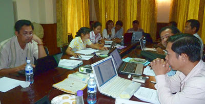 Left: Staff of the GIS and Remote Sensing unit of the Forestry Administration, Cambodia, attending the GRAS training in “Satellite remote sensing in support of UN-REDD”.
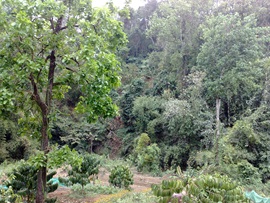
Top: Forest in Cambodia's eastern Mondulkiri province (© Dtfman / CC-BY-SA-3.0)