GIS day 2011
Each year in November, the global community celebrates the annual GIS day. Let’s take the opportunity to showcase what DHI and GIS can do for you!
What is GIS?
GIS - short for Geographical Information System - is a system that allows one to discover previously unnoticed patterns, relationships, and trends in data. Moreover, it enables you to manage your data, perform advanced analysis, model and automate operational processes, and display your results on professional-quality maps.
DHI and GIS: Visualize your data, ask the right questions, strengthen your decisions
GIS plays an important role in the daily work carried out by our in-house experts in many DHI offices. Combining GIS with our state-of-the-art numerical models and our wide-ranging expertise in the world of water, DHI can supply you with complete solutions tailored to your specific needs. Depending on your project, this can range from standardized storage, cartography and documentation of GIS data and maps, to customizing a dynamic, web-based GIS framework with advanced display, query and presentation capabilities.
DHI’s GIS services include:
• Collection, integration and analysis of geographic data from various sources
• Visual and easily understandable presentation of complex ideas
• Easy access to data for decision makers, analysts and fieldworkers
• Identification and visualisation of spatial patterns that may not be apparent in tables & charts
• Spatial analysis of data to ask & answer specific questions (e.g. is coral bleaching worse outside a marine protected area?)
• Strengthened scientific basis for decision making
Learn more…
See some examples of how our GIS-Solutions help our clients:
|
Operational disaster management with GeoFES
|
GeoFES is a software that backs decision makers at fire brigades and disaster management services. Developed by DHI Germany, GeoFES supports efficient action in the event of fires, natural disasters (storms, floods), anthropogenic environmental changes, nuclear, biological and chemical (NBC) incidents, epidemics and accidents. It can also be used for preventive planning and training purposes. |
|
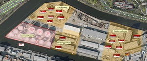 |
See how GeoFES helps fire brigades in an emergency simulation @ http://www.youtube.com/user/DHIGroup
More info @ http://www.dhigroup.com/SolutionSoftware/GeoFES.aspx |
|
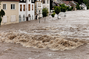
Flood risk management with the Flood Toolbox
|
The modular Flood Toolbox allows for Flood protection, prevention, management and damage assessment, i.a. supporting the implementation of the EU Flood Directive. |
|
 |
| More info @ http://www.dhigroup.com/News/2011/03/07/ThePerfectToolboxForFloodRiskManagement.aspx |
|
|
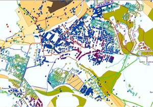
Reducing leakage in urban water systems
|
DHI enables successful urban water management and leakage monitoring thanks to precise metering of the amount of water entering and leaving a specific area and identification of priority mitigation measures. |
|
 |
| More info at @ http://www.scribd.com/doc/69541148/Successful-water-management-in-cities-DHI-case-story-CZ http://www.scribd.com/doc/69541941/Reduce-non-revenue-water-in-water-utilities-–-DHI-solution |
|
|
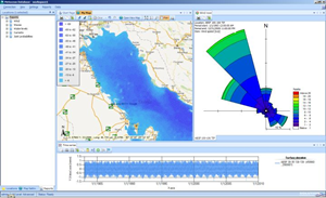
Operational forecasts of MetOcean data
|
Info@SEA offers high-resolution forecasts of tides, water levels, waves and surges based on DHI’s models. Subscribers, e.g. from the maritime, offshore, engineering and recreational community, are offered forecasts tailored to their specific needs and requirements, which are available from our website and via email and SMS. More info @ www.sea.com.sg |
|
 |
|
|
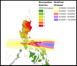
Enabling insurance solutions against extreme weather
|
Detailed rain and wind data enable the classification of typhoons on the Philippines, allowing for microinsurer’s solutions against such natural catastrophes to protect the local communities and cooperatives from insolvency. |
|
 |
| More info at @ http://www.scribd.com/doc/69541196/Tailor-made-insurances-against-natural-catastrophes-DHI-case-story-SG |
|
|
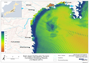
Natural catastrophe protection
|
Floods, tsunamis, typhoons – the number and severity of such catastrophes increases in the wake of climate change. Global Cat(astrophe) Eye works to reduce losses by providing timely forecasts, model results, analysis and knowledge based, comprehensive expertise across disciplines to minimize and mitigate the impact of catastrophes globally. More info @ http://www.globalcateye.com |
|
 |
|
|
Training & Education
|
DHI-NTU Education Hub conducts a variety of workshops, executive and expert courses in GIS for working professionals in the water- and environment-related industry. Workshops & courses can be customised to meet your needs. |
|
|
| More info @ http://www.dhi-ntu.com.sg/Education/Workshops.aspx |
|
|