Monitoring of water supply through simulation and access to real-time data
Founded in 1909 as the municipality of Rome’s electric company, ACEA is a listed industrial group and one of the most important national public utility operators in Italy. Together with DHI Czech Republic and a local partner, DHI Italy has helped them develop a WebGIS-based platform integrating MIKE URBAN to estimate the operating parameters of their water networks.
In 2014, the ACEA Group launched a project to develop and integrate information systems used by various sectors within its group of companies. The aim was to increase the efficiency of their processes by creating a single integrated system in their geographical information system (GIS) Platform, ESRI.
DHI Italy is working to ensure that MIKE Powered by DHI’s products is a forerunner and the industry standard when it comes to water modelling. Our WebGIS-based platform showcases the importance of water modelling for utility operators and demonstrates GIS-integrated modelling using MIKE URBAN.
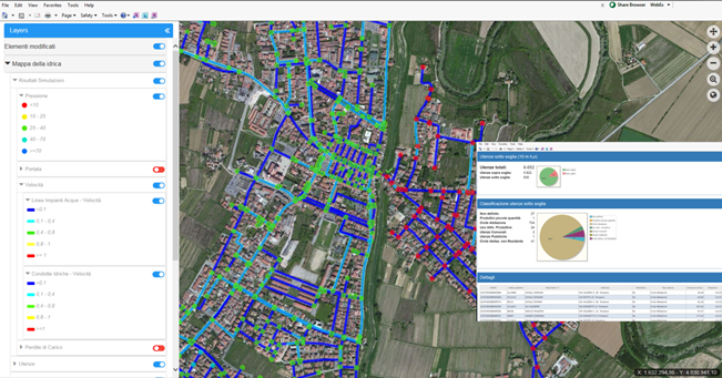
The application, with a MIKE URBAN Water Distribution (WD) model running in the background, takes into account real-time scenarios of the network and possible scenarios defined by the user, such as the open/close element status and different demands of district metering areas (DMAs). The main functionalities are:
- Selection of the network based on a list of validated model setups
- Import of GIS features and update of the MIKE URBAN WD model
- Running of the actual network status (demand from SCADA system as well as element status from GIS and SCADA)
- Evaluation of network current status (maximum/minimum pressure, velocity and discharge in pipes)
- Creation of user scenarios (changing element status or actual demand)
- Evaluation of scenarios impact (pressure, velocity and discharge)
- List of customers with service disruptions
 |
|
View of the WebGIS-based platform we developed for the ACEA Group. © DHI |
Watch a video preview of the platform
here.
Read more